Images

Save up to £160*

UK Curriculum Pack

Product Code: GE10093
A collection of maps and materials designed for in-depth study of the United Kingdom's geography.
Read more

Promotions

Product Actions

Add to cart options

Variations

Please make all your selections
£30.99 ex VAT £ 37.19 inc VAT

In Stock

Please make a selection

Product Information

Overview

    Product Includes

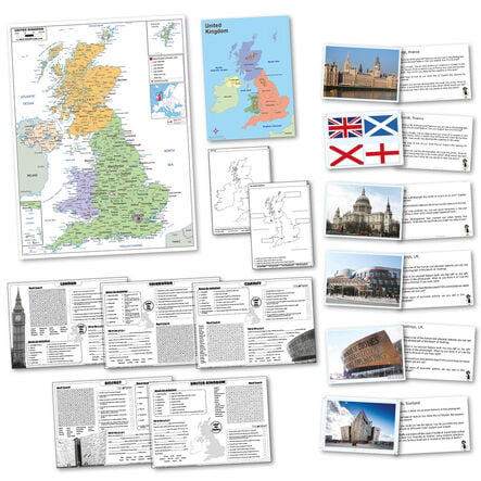
  • 1 x A1 Political Map of the UK, 1 x A3 Simple Map of the UK, 2 x A4 Photocopiable Activity Sheets, 5 x A3 Photocopiable Quizpad, 6 x A4 Photocards and Activities

  • Pack Size

  • 15

Helping to Support Teaching and Learning

Comprehensive Map Selection

This pack contains A1 Political and A3 Simple UK maps, along with A4 photocards designed to support geographical education.

UK Study Resources

Includes maps and activity resources, offering practical aids to teach about the regions of the United Kingdom.

Interactive Learning Tools

Features photocopiable activity sheets that encourage students to engage with geographical content through hands-on tasks.

Skill Development

Equipped with various maps and resource materials that aid in developing practical skills in navigation and geography.

Geographical Skills Enhancement

Facilitates Key Stage 1 and 2 explorations of the United Kingdom with detailed maps and organised activities, matching curriculum needs.

Your TTS photos

Tag your photos #takingoverTTS

UK Curriculum Pack

A collection of maps and materials designed for in-depth study of the United Kingdom's geography.

Overview

  • Supports UK geographical studies through various maps and resources, aligned with Key Stage curriculums.

  • This robust pack is essential for enhancing UK geography education from Key Stage 1 to Key Stage 2. It includes an A1 Political Map of the UK, an A3 Simple Map of the UK, and various comprehensible activity resources.

  • Equip learners with hands-on activities using six A4 photocards and activities that make learning interactive and engaging. This allows children to explore geographic concepts practically and visually.

  • Suitably aligned with the national curriculum, this pack aids in developing a comprehensive understanding of geographical skills and fieldwork using atlases, maps, and globes, fostering a deeper knowledge of the UK and the wider world.

Supports the National Curriculum

Geography, Key Stage 1, Geographical Skills & Fieldwork

Use world maps, atlases and globes to identify the United Kingdom and its countries, as well as the countries, continents and oceans studied at this key stage.

Geography, Key Stage 2, Place Knowledge

Understand geographical similarities and differences through the study of human and physical geography of a region of the United Kingdom, a region in a European country and North or South America.

Geography, Key Stage 2, Geographical Skills & Fieldwork

Use the 8 points of a compass, 4- and 6-figure grid references, symbols and key (including the use of Ordnance Survey maps) to build their knowledge of the United Kingdom and the wider world.

Product Information

Overview

    Product Includes

  • 1 x A1 Political Map of the UK, 1 x A3 Simple Map of the UK, 2 x A4 Photocopiable Activity Sheets, 5 x A3 Photocopiable Quizpad, 6 x A4 Photocards and Activities

  • Pack Size

  • 15

Questions

Reviews