Images

Save up to £100*

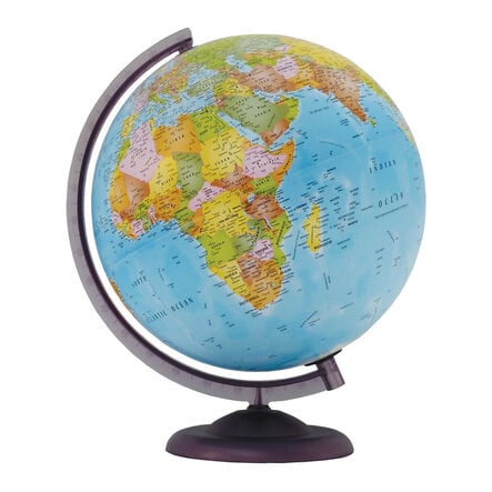
Economy Political World Globes with Stand

Product Code: make all selections to view product code
Colour-coded globe with over 2,500 place names, mounted on a durable plastic base.
Read more

Promotions

Product Actions

Add to cart options

Variations

Please make all your selections
From £32.99 ex VAT
Please make a selection

Helping to Support Teaching and Learning

Political Cartography

The globe’s detailed political cartography clearly marks boundaries and over 2,500 place names, making it an effective tool for teaching locational knowledge.

Durable Base

Constructed from durable plastic, the base provides stability and longevity, ensuring the globe remains a reliable classroom resource.

Clear Labelling

Continent and ocean names are labelled in a larger font, making them easy to read and identify. Capital cities are emboldened and marked with a larger black star.

Ocean Features

Relevant ocean features such as ridges, rises, trenches, and basins are included, providing comprehensive geographical information.

Locational Knowledge

Supports Key Stage 2 geography by helping children name and locate counties and cities of the United Kingdom, geographical regions, and their characteristics.

Your TTS photos

Tag your photos #takingoverTTS

Economy Political World Globes with Stand

Colour-coded globe with over 2,500 place names, mounted on a durable plastic base.

Overview

  • Enhance geography lessons with this essential globe. Addressing the need for accurate geographical understanding, its detailed political cartography aids children in grasping political boundaries and locating over 2,500 places. The sturdy plastic base ensures stable classroom use.

  • Benefiting the Key Stage 2 geography curriculum, the globe helps children name and locate UK counties and cities, and explore regions and their characteristics. It also facilitates learning about countries worldwide, focusing on Europe’s environmental regions and major cities.

  • Supporting geographical skills and fieldwork, the globe includes compass points, grid references, symbols, and keys to expand knowledge of the UK and the wider world. It features oceanic details like ridges, rises, trenches, basins, and the International Date Line.

Supports the National Curriculum

Geography, Key Stage 2, Locational Knowledge

Name and locate counties and cities of the United Kingdom, geographical regions and their human and physical characteristics, key topographical features and land-use patterns and changes over time.

Geography, Key Stage 2, Locational Knowledge

Locate the world’s countries, using maps to focus on Europe concentrating on their environmental regions, key physical and human characteristics, countries, and major cities.

Geography, Key Stage 2, Geographical Skills & Fieldwork

Use the 8 points of a compass, 4- and 6-figure grid references, symbols and key (including the use of Ordnance Survey maps) to build their knowledge of the United Kingdom and the wider world.

Questions

Reviews