Images

UK Physical Map A1

Product Code: GE00527
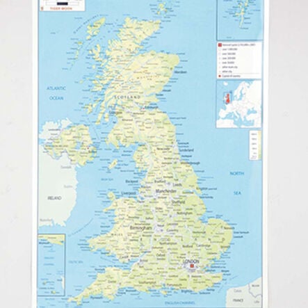
A detailed physical map of the UK, detailing the cities and towns.
Read more

Product Actions

Add to cart options

Variations

Please make all your selections
£22.99 ex VAT £ 22.99 inc VAT

In Stock

Technical Summary

Overview

Helping to Support Teaching and Learning

Detailed Topography

This map vividly illustrates the UK's physical landscape with detailed labelling of cities, towns, and significant natural features.

Educational Relevance

Aligned with Key Stage 2 and 3 requirements, this resource aids in the development of geographical skills through the use of maps, atlases, and globes.

Robust Material

Constructed from durable laminate, this A1-sized map offers a useful resource for teaching key geographical concepts.

Geographical Skills Enhancement

Supports learning of UK geography such as hills, rivers, and cities, aligning with educational goals.

Locational Knowledge

Enhances locational knowledge by enabling children to identify and describe major UK counties and cities, and their key geographical features.

Your TTS photos

Tag your photos #takingoverTTS

UK Physical Map A1

A detailed physical map of the UK, detailing the cities and towns.

Overview

  • This educational map is an effective tool for enhancing geographical knowledge in Key Stage 2 pupils. It focuses on teaching the use of maps, atlases, globes, and digital mapping to understand the geographical features of the United Kingdom. Pupils learn to locate various landmarks while building familiarity with map symbols and grid references.

  • The map supports curriculum aims involving compass points, grid references, and symbol interpretation through practical application. As pupils explore detailed markings of cities, rivers, mountains, and other features on this A1 laminated map, they gain skills in navigation and geographical recognition.

  • Additionally, this resource helps teach locational knowledge, enabling pupils to name and locate key UK counties and cities. They will understand the physical and human characteristics that define different regions, such as land use patterns and topographical changes over time, making the map a vital part of engaging geography lessons.

Supports the National Curriculum

Geography, Key Stage 2, Geographical Skills & Fieldwork

Use maps, atlases, globes and digital/computer mapping to locate countries and describe features studied.

Geography, Key Stage 2, Geographical Skills & Fieldwork

Use the 8 points of a compass, 4- and 6-figure grid references, symbols and key (including the use of Ordnance Survey maps) to build their knowledge of the United Kingdom and the wider world.

Geography, Key Stage 2, Locational Knowledge

Name and locate counties and cities of the United Kingdom, geographical regions and their human and physical characteristics, key topographical features and land-use patterns and changes over time.

Technical Summary

Overview

    Material

  • Laminate

  • Age Range

  • Suitable for 7 to 11 years

Size and measurements

    Paper size

  • A1

Questions

Reviews