Images

Save up to £200*

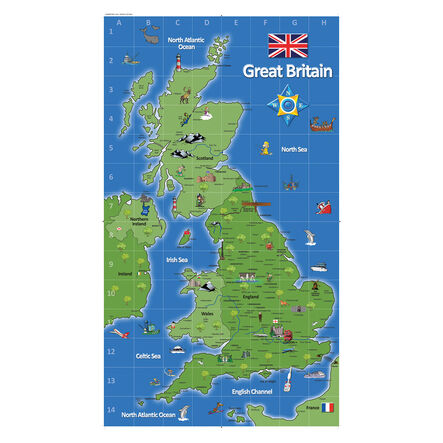
UK Deskmat A2 6pk

Product Code: GE00611
Explore the UK with these A2-sized laminated deskmats designed for interactive geography learning.
Read more

Promotions

Product Actions

Add to cart options

Variations

Please make all your selections
£32.99 ex VAT £ 39.59 inc VAT

Hurry, less than 10 available

Product Information

Overview

Helping to Support Teaching and Learning

Durable Laminated Surface

Constructed from laminate, these deskmats offer a surface that allows children to write on and wipe off information, facilitating repeated use.

Supports Key Stage 1 Geography

Designed for Key Stage 1, using maps and atlases, these deskmats allow children to locate and identify the UK and its countries as they learn.

Enhances Map Reading Skills

Geared towards Key Stage 2 needs, these deskmats support the curriculum by helping children use maps to find countries and describe geographic features.

UK Locational Knowledge

These deskmats aid children in naming and locating counties and cities within the UK, as well as understanding the geographic regions and their features.

Interactive Learning Tool

The deskmats support geographic education, enhancing the engagement with curriculum content from Key Stage 1 to Key Stage 2.

Your TTS photos

Tag your photos #takingoverTTS

UK Deskmat A2 6pk

Explore the UK with these A2-sized laminated deskmats designed for interactive geography learning.

Overview

  • The deskmats are tailored to enhance learning by offering a laminated surface for map-based activities. They align with UK curriculum needs, supporting tasks that involve identification and description of geographic locations.

  • Supporting curriculum objectives from Key Stage 1 to Key Stage 2, these deskmats are pivotal for teaching basic geographical locations like counties, cities, and regions in the UK.

  • Designed to facilitate interaction, these laminated deskmats empower children to explore geographical concepts through hands-on learning, improving retention through engaging teaching methods.

Supports the National Curriculum

Geography, Key Stage 1, Geographical Skills & Fieldwork

Use world maps, atlases and globes to identify the United Kingdom and its countries, as well as the countries, continents and oceans studied at this key stage.

Geography, Key Stage 2, Geographical Skills & Fieldwork

Use maps, atlases, globes and digital/computer mapping to locate countries and describe features studied.

Geography, Key Stage 2, Locational Knowledge

Name and locate counties and cities of the United Kingdom, geographical regions and their human and physical characteristics, key topographical features and land-use patterns and changes over time.

Product Information

Overview

    Pack size

  • 6

  • Material

  • Laminate

  • Age Range

  • Suitable for 5 to 11 years

Size and measurements

    Paper size

  • A2

Questions

Reviews