Images

Save up to £160*

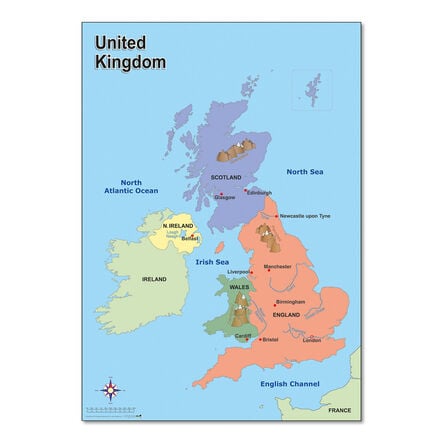
Map of the UK A1

Product Code: GE10097
A detailed A1-sized map of the UK featuring major towns, cities, rivers, and mountains.
Read more

Promotions

Product Actions

Add to cart options

Variations

Please make all your selections
£16.75 ex VAT £ 20.10 inc VAT

In Stock

Please make a selection

Product Information

Sizes and Measurements

    Paper Size

  • A1

Helping to Support Teaching and Learning

Detailed UK Representation

This map details the UK's major towns, cities, rivers, and mountains, making it essential for geographical education.

Curriculum Support

This map helps teach Key Stage 1 Geography, focusing on locational knowledge and geographical skills with clear visuals.

Enhanced Learning Tool

This map facilitates an understanding of the UK's landscapes, supporting discussions on geographical similarities and differences.

Interactive Classroom Resource

Facilitates in-depth geography lessons through interactions with major geographic features of the UK, enhancing classroom engagement.

Geographical Skills Development

Supports geographical curriculum at Key Stage 1 by aiding teaching on UK locational knowledge through clear, visual learning tools.

Your TTS photos

Tag your photos #takingoverTTS

Map of the UK

A detailed A1-sized map of the UK featuring major towns, cities, rivers, and mountains.

Overview

  • A useful tool for Key Stage 1 and 2 geography, focusing on the UK's geography, enhancing map reading skills and locational knowledge.

  • This educational A1 map of the UK is meticulously designed to enhance the geographical knowledge of children at Key Stage 1 and 2. It features high-quality representations of major towns, cities, rivers, and mountains, making it an invaluable resource for supporting geographical skills and fieldwork.

  • By enabling children to identify the UK and its key aspects using atlases and globes, this map promotes critical thinking and spatial awareness in an engaging manner. As part of their geographical studies, children can explore the diverse landscapes and development of locational knowledge.

  • In addition, the map serves as a tool for contrasting studies, allowing children to compare the human and physical geography of the UK with that of non-European countries. This lays a foundation for understanding global geographical nuances through practical map-reading exercises.

Supports the National Curriculum

Geography, Key Stage 1, Geographical Skills & Fieldwork

Use world maps, atlases and globes to identify the United Kingdom and its countries, as well as the countries, continents and oceans studied at this key stage.

Geography, Key Stage 1, Locational Knowledge

Name, locate and identify characteristics of the 4 countries and capital cities of the United Kingdom and its surrounding seas.

Geography, Key Stage 1, Place Knowledge

Understand geographical similarities and differences through studying the human and physical geography of a small area of the United Kingdom, and of a small area in a contrasting non-European country.

Product Information

Sizes and Measurements

    Paper Size

  • A1

Questions

Reviews