Images

Save up to £160*

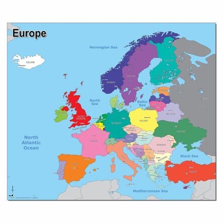
Map of Europe A1

Product Code: GH47381
Very clear and attractive map of Europe that shows country borders, capital cities, and oceans.
Read more

Promotions

Product Actions

Add to cart options

Variations

Please make all your selections
£15.50 ex VAT £ 15.50 inc VAT

In Stock

Please make a selection

Helping to Support Teaching and Learning

Map Reading

Good to teach map reading to children. The clear layout helps children understand geographical concepts and improve their locational knowledge.

Clear Borders

Colourful and easy-to-see borders allow children to distinguish between different countries easily. This visual clarity enhances their learning experience.

Large Size

The large A1 size makes all details easily visible, making it suitable for classroom wall displays and group activities.

Supports KS1 Geography

Helps children name and locate the world's seven continents and five oceans. It also helps children use maps, atlases, and globes to identify the United Kingdom and its countries.

Locational Knowledge

Helps locate the world's countries, with a focus on Europe. Supports understanding of environmental regions, key physical and human characteristics, and major cities.

Your TTS photos

Tag your photos #takingoverTTS

Map of the Europe A1

Very clear and attractive map of Europe that shows country borders, capital cities, and oceans.

Overview

  • Supports KS1 and KS2 geography studies. Enhances map reading, locational knowledge, and understanding of contrasting localities.

  • Teachers will find this colourful Europe map an excellent resource for geography lessons. It displays country borders, capital cities, and oceans, making it useful for teaching locational knowledge and skills. Its large A1 size ensures details are easily visible for group learning.

  • In Key Stage 2 geography, the map helps children locate the world's countries, focusing on Europe and understanding regions, key characteristics, and major cities.

  • For Key Stage 1, it aids in teaching compass directions and locational language. Children can describe locations, name continents and oceans, and identify the United Kingdom and its countries. The map supports using maps, atlases, and globes in geography lessons.

Supports the National Curriculum

Geography, Key Stage 2, Locational Knowledge

Locate the world’s countries, using maps to focus on Europe concentrating on their environmental regions, key physical and human characteristics, countries, and major cities.

Geography, Key Stage 2, Place Knowledge

Understand geographical similarities and differences through the study of human and physical geography of a region of the United Kingdom, a region in a European country and North or South America.

Geography, Key Stage 1, Geographical Skills & Fieldwork

Use simple compass directions and locational and directional language, to describe the location of features and routes on a map.

Questions

Reviews