Images

Save up to £160*

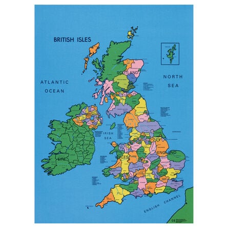
Drywipe Map of the British Isles 91cm x 71cm

Product Code: GE10084
An interactive political map of the British Isles with a drywipe surface for dynamic teaching.
Read more

Promotions

Product Actions

Add to cart options

Variations

Please make all your selections
£24.99 ex VAT £ 29.99 inc VAT

In Stock

Please make a selection

Product Information

Sizes and Measurements

    Height

  • 91 cm

  • Width

  • 71 cm

  • Dimensions

  • H91 x W71cm

Helping to Support Teaching and Learning

Interactive Learning

Designed for engagement, this map allows children to write, draw, and annotate directly on its surface, fostering interactive learning experiences.

Reusable Resource

With a drywipe surface, this map is easily wiped clean, making it a sustainable, reusable resource for countless geography lessons.

UK Geography Aid

Ideal for teaching UK political cartography, this map enhances understanding of the British Isles' geographical and political landscapes.

Curriculum Support

Aligns with Key Stage 1 and 2 Geography curriculums, supporting locational knowledge and geographical skills development.

Geographical Skills

Supports Key Stage 1 curriculum by aiding in the use of world maps and atlases to identify the UK, its countries, and major geographical features.

Your TTS photos

Tag your photos #takingoverTTS

Drywipe Map of the British Isles 91cm x 71cm

An interactive political map of the British Isles with a drywipe surface for dynamic teaching.

Overview

  • Enhance geography lessons with this reusable map, allowing children to mark and erase towns, cities, and geographical features.

  • Explore the versatile Drywipe Map of the British Isles, an essential H91 x W71cm teaching tool that brings geography lessons to life. Made from 100% cotton with a plastic coating, it allows for easy annotation and wiping clean, perfect for repeated use in the classroom.

  • At Key Stage 1, it helps children recognise the geographical distinctions between the UK, Great Britain, and the British Isles, thereby enriching their understanding of locational knowledge. For Key Stage 2, it becomes an indispensable resource for delving into the UK's counties, cities, and diverse geographical regions, encouraging an interactive learning experience.

  • Crafted for durability and designed to support the geography curriculum across Key Stages 1 and 2, this map fosters an engaging educational environment. It serves as a dynamic platform for children to explore, annotate, and understand the UK's political and geographical contours, making it a key resource for enhancing geographical awareness.

Supports the National Curriculum

Geography, Key Stage 1, Geographical Skills & Fieldwork

Use world maps, atlases and globes to identify the United Kingdom and its countries, as well as the countries, continents and oceans studied at this key stage.

Geography, Key Stage 1, Locational Knowledge

Name, locate and identify characteristics of the 4 countries and capital cities of the United Kingdom and its surrounding seas.

Geography, Key Stage 2, Geographical Skills & Fieldwork

Use maps, atlases, globes and digital/computer mapping to locate countries and describe features studied.

Product Information

Sizes and Measurements

    Height

  • 91 cm

  • Width

  • 71 cm

  • Dimensions

  • H91 x W71cm

Questions

Reviews