Globes can be found in most primary classrooms. How can we ensure that they are not just decoration, but an integral part of developing children’s geographical knowledge?
Here’s how you can use TTS globes that are appropriate for the knowledge required at each phase to support progression across your school.
Early Years
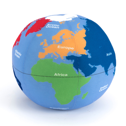
This soft globe is useful for introducing children to vocabulary and concepts they will meet further up the school. Although there is no specific requirement for Early Years children to use globes, having some globes in the classroom for children to discuss and explore through play will ensure that they are familiar with what a globe is – that it represents the earth and is a 3d version of the world map, showing continents and oceans.
Key Stage 1
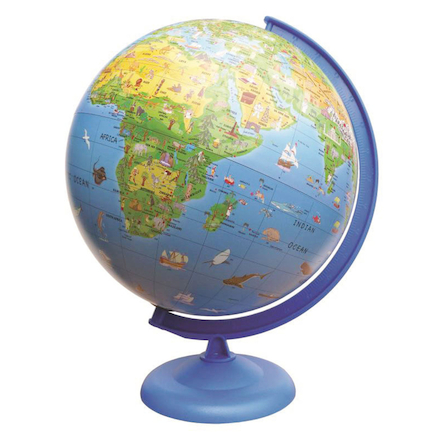
This activity globe is particularly suitable for children in KS1. The seven continents and five oceans are clearly marked, as well as hot and cold areas of the world. As well as these, at this stage children are expected to locate the UK and other countries they have studied on a globe. The activity globe makes it easy for children to do this, as there are engaging images to make countries more easily identifiable, and to enable children to start comparing places.
By the end of KS1, children would be expected to know:
- That we live on the planet Earth which is one of 8 planets that orbit the Sun in our solar system (brief intro as preparation for Year 5 science)
- That a globe represents the Earth
- That a globe is a sphere which is spherical, and this is the same shape as the planet Earth
- That the blue areas of the globe represent water, and the green/brown/yellow areas represent land
- That the northernmost point of the globe is the North Pole, and the southernmost point of the globe is the South Pole
- That there is an imaginary line round the centre of the globe, which is called the Equator
- That the temperature is hotter near the Equator, and colder near the North and South Poles
Key Stage 2
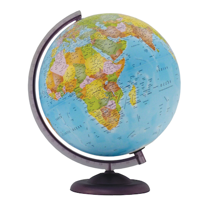
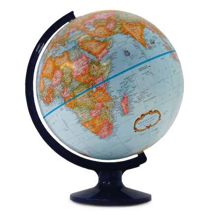
As children progress into KS2, they will be expected to identify countries and physical features on more abstract globes. The Economy Globe clearly shows political boundaries and significant physical features, while the Maddison globe has tactile representations of land height, as well as showing lines of latitude and longitude. Use of these globes should be built into any lessons involving locating world countries, physical features such as deserts and mountains, and learning about the Earth as a planet, such as in science learning about day and night, or the geography of time zones. Children should use more specific vocabulary to describe the features of the globe, as set out below.
By the end of KS2, children should know:
- The Equator bisects the globe. The two halves are called the northern and southern hemispheres (hemi meaning half). The North Pole is in the northern hemisphere, and the South Pole is in the southern hemisphere.
- There are 180 imaginary lines that form parallel east-west circles around the Earth. They are called lines of latitude and they measure distance north or south of the Equator (measured in degrees).
- The Equator is a line of latitude (0°)
- The Arctic Circle (66.5° north) is a line of latitude, which is the most northerly of the major circles of latitude. The region north of the Arctic Circle is known as the Arctic.
- The Antarctic Circle (66.5° south) is a line of latitude, which is the most southerly of the major circles of latitude. The region south of the Antarctic Circle is known as the Antarctic.
- The areas inside the Arctic and Antarctic Circles experience a polar climate, because they receive less direct sunlight than other parts of the world.
- Within polar regions, days are very short in winter, and very long in summer, due to the tilt of the Earth.
- The Tropics of Cancer (23.5° north) and Capricorn (23.5° south) are lines of latitude. The region between these two lines of latitude is known as the tropics, and experiences a tropical climate, because this is the region of the Earth which receives direct sunlight.
- Near the Equator, the length of the day is similar all year round, because these areas always receive more direct sunlight.
- Lines of longitude are imaginary semi-circles, running from one pole to the other. They are also called meridians.
- The Prime/Greenwich Meridian (0° ) is a line of longitude which runs through Greenwich in London. It is the point from which all other lines of longitude are measured, east or west, in the same way that lines of latitude are measured north or south of the Equator.
- Time zones are divided by lines of longitude (meridians). All the places in each time zone use the same time, but when we travel from one time zone to another, we add or lose one hour. This is due to the Earth’s rotation on its axis, meaning that at any one time, different parts of the world are facing the Sun. Some countries fall within one time zone, but some large countries, such as Russia and the USA, cross several different time zones.
All of these objectives should be demonstrated using a globe, and children should have the opportunity to explore globes independently in order to reinforce what they have learnt and to develop a strong understanding of the structure of the world.
Explore the full range of globes
With many thanks to Victoria Morris for writing this blog.
Victoria is a Deputy Headteacher, teacher and curriculum expert.
Read more from Victoria on her own blog, MrsSTeaches on Curriculum.


