Images
Save up to £100*


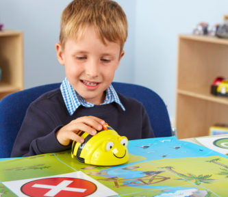
Bee-Bot® European Map
Details
https://www.tts-group.co.uk/bee-bot-european-map/1009030.htmlProduct Code: make all selections to view product code
Bright, engaging and highlights the physical locations of countries, capitals, seas and oceans.
Read more
Promotions
SITE WIDE SPEND & SAVE* Spend £200, Save £20! Spend £400, Save £50! Spend £600 save £100! Code : SPRING24
Details
 Terms and conditions: 1. This offer is valid until 23.05.2024 and applies to selected full priced qualifying items only. 2. Cannot be used in conjunction with any other offers and is subject to availability. 3. This offer can only be used once per customer. 4. TTS Group reserve the right to change these terms & conditions on reasonable notice. 5. Offer is only open to customers based in the UK (inc. Channel Islands and Isle of Man). 6. Discounts are applied to the ex-VAT sub-total amount. 7. Offer is applicable online only and excludes Items included in other promotions. 8. Code: SPRING24 must be added into the basket to activate promotion and is only valid on orders placed online. 9. Use of the code SPRING24 will supersede any other promotions that may have been activated. 1. Excludes Selected Items due to stock position 1. Other exclusions may apply.
Product Actions
Why you'll love this product
- Use on the floor with Bee-Bot® or on the wall
- A colourful map that clearly highlights physical geography worldwide
- Images encourage further discussion about human characteristics
Featured and Inspired By
Get the most out of your Bee-Bot® European Map by taking inspiration